
AIM Text
- Introduction. The Traffic Information Service (TIS) provides information to the cockpit via data link, that is similar to VFR radar traffic advisories normally received over voice radio. Among the first FAA-provided data services, TIS is intended to improve the safety and efficiency of “see and avoid” flight through an automatic display that informs the pilot of nearby traffic and potential conflict situations. This traffic display is intended to assist the pilot in visual acquisition of these aircraft. TIS employs an enhanced capability of the terminal Mode S radar system, which contains the surveillance data, as well as the data link required to “uplink” this information to suitably-equipped aircraft (known as a TIS “client”). TIS provides estimated position, altitude, altitude trend, and ground track information for up to 8 intruder aircraft within 7 NM horizontally, +3,500 and -3,000 feet vertically of the client aircraft (see FIG 4-5-3, TIS Proximity Coverage Volume). The range of a target reported at a distance greater than 7 NM only indicates that this target will be a threat within 34 seconds and does not display a precise distance. TIS will alert the pilot to aircraft (under surveillance of the Mode S radar) that are estimated to be within 34 seconds of potential collision, regardless of distance or altitude. TIS surveillance data is derived from the same radar used by ATC; this data is uplinked to the client aircraft on each radar scan (nominally every 5 seconds).
- Requirements.
- In order to use TIS, the client and any intruder aircraft must be equipped with the appropriate cockpit equipment and fly within the radar coverage of a Mode S radar capable of providing TIS. Typically, this will be within 55 NM of the sites depicted in FIG 4-5-4, Terminal Mode S Radar Sites. ATC communication is not a requirement to receive TIS, although it may be required by the particular airspace or flight operations in which TIS is being used.
FIG 4-5-3
TIS Proximity Coverage Volume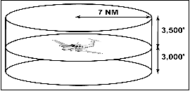
FIG 4-5-4
Terminal Mode S Radar Sites
FIG 4-5-5
Traffic Information Service (TIS)
Avionics Block Diagram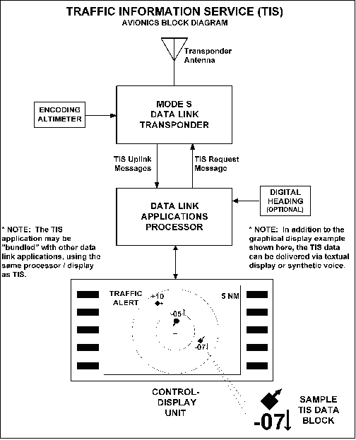
- The cockpit equipment functionality required by a TIS client aircraft to receive the service consists of the following (refer to FIG 4-5-5):
- Mode S data link transponder with altitude encoder.
- Data link applications processor with TIS software installed.
- Control-display unit.
- Optional equipment includes a digital heading source to correct display errors caused by “crab angle” and turning maneuvers.
- To be visible to the TIS client, the intruder aircraft must, at a minimum, have an operating transponder (Mode A, C or S). All altitude information provided by TIS from intruder aircraft is derived from Mode C reports, if appropriately equipped.
- TIS will initially be provided by the terminal Mode S systems that are paired with ASR-9 digital primary radars. These systems are in locations with the greatest traffic densities, thus will provide the greatest initial benefit. The remaining terminal Mode S sensors, which are paired with ASR-7 or ASR-8 analog primary radars, will provide TIS pending modification or relocation of these sites. See FIG 4-5-4, Terminal Mode S Radar Sites, for site locations. There is no mechanism in place, such as NOTAMs, to provide status update on individual radar sites since TIS is a nonessential, supplemental information service.
The FAA also operates en route Mode S radars (not illustrated) that rotate once every 12 seconds. These sites will require additional development of TIS before any possible implementation. There are no plans to implement TIS in the en route Mode S radars at the present time.
- In order to use TIS, the client and any intruder aircraft must be equipped with the appropriate cockpit equipment and fly within the radar coverage of a Mode S radar capable of providing TIS. Typically, this will be within 55 NM of the sites depicted in FIG 4-5-4, Terminal Mode S Radar Sites. ATC communication is not a requirement to receive TIS, although it may be required by the particular airspace or flight operations in which TIS is being used.
- Capabilities.
- TIS provides ground-based surveillance information over the Mode S data link to properly equipped client aircraft to aid in visual acquisition of proximate air traffic. The actual avionics capability of each installation will vary and the supplemental handbook material must be consulted prior to using TIS. A maximum of eight (8) intruder aircraft may be displayed; if more than eight aircraft match intruder parameters, the eight “most significant” intruders are uplinked. These “most significant” intruders are usually the ones in closest proximity and/or the greatest threat to the TIS client.
- TIS, through the Mode S ground sensor, provides the following data on each intruder aircraft:
- Relative bearing information in 6-degree increments.
- Relative range information in 1/8 NM to 1 NM increments (depending on range).
- Relative altitude in 100-foot increments (within 1,000 feet) or 500-foot increments (from 1,000-3,500 feet) if the intruder aircraft has operating altitude reporting capability.
- Estimated intruder ground track in 45-degree increments.
- Altitude trend data (level within 500 fpm or climbing/descending >500 fpm) if the intruder aircraft has operating altitude reporting capability.
- Intruder priority as either an “traffic advisory” or “proximate” intruder.
- When flying from surveillance coverage of one Mode S sensor to another, the transfer of TIS is an automatic function of the avionics system and requires no action from the pilot.
- There are a variety of status messages that are provided by either the airborne system or ground equipment to alert the pilot of high priority intruders and data link system status. These messages include the following:
- Alert. Identifies a potential collision hazard within 34 seconds. This alert may be visual and/or audible, such as a flashing display symbol or a headset tone. A target is a threat if the time to the closest approach in vertical and horizontal coordinates is less than 30 seconds and the closest approach is expected to be within 500 feet vertically and 0.5 nautical miles laterally.
- TIS Traffic. TIS traffic data is displayed.
- Coasting. The TIS display is more than 6 seconds old. This indicates a missing uplink from the ground system. When the TIS display information is more than 12 seconds old, the “No Traffic” status will be indicated.
- No Traffic. No intruders meet proximate or alert criteria. This condition may exist when the TIS system is fully functional or may indicate “coasting” between 12 and 59 seconds old (see (c) above).
- TIS Unavailable. The pilot has requested TIS, but no ground system is available. This condition will also be displayed when TIS uplinks are missing for 60 seconds or more.
- TIS Disabled. The pilot has not requested TIS or has disconnected from TIS.
- Good-bye. The client aircraft has flown outside of TIS coverage.
- Depending on avionics system design, TIS may be presented to the pilot in a variety of different displays, including text and/or graphics. Voice annunciation may also be used, either alone or in combination with a visual display. FIG 4-5-5, Traffic Information Service (TIS), Avionics Block Diagram,shows an example of a TIS display using symbology similar to the Traffic Alert and Collision Avoidance System (TCAS) installed on most passenger air carrier/commuter aircraft in the U.S. The small symbol in the center represents the client aircraft and the display is oriented “track up,” with the 12 o'clock position at the top. The range rings indicate 2 and 5 NM. Each intruder is depicted by a symbol positioned at the approximate relative bearing and range from the client aircraft. The circular symbol near the center indicates an “alert” intruder and the diamond symbols indicate “proximate” intruders.
- The inset in the lower right corner of FIG 4-5-5, Traffic Information Service (TIS), Avionics Block Diagram,shows a possible TIS data block display. The following information is contained in this data block:
- The intruder, located approximately four o'clock, three miles, is a “proximate” aircraft and currently not a collision threat to the client aircraft. This is indicated by the diamond symbol used in this example.
- The intruder ground track diverges to the right of the client aircraft, indicated by the small arrow.
- The intruder altitude is 700 feet less than or below the client aircraft, indicated by the “-07” located under the symbol.
- The intruder is descending >500 fpm, indicated by the downward arrow next to the “-07” relative altitude information. The absence of this arrow when an altitude tag is present indicates level flight or a climb/descent rate less than 500 fpm.
- Limitations.
- TIS is NOT intended to be used as a collision avoidance system and does not relieve the pilot's responsibility to “see and avoid” other aircraft (see paragraph 5-5-8, See and Avoid). TIS must not be used for avoidance maneuvers during IMC or other times when there is no visual contact with the intruder aircraft. TIS is intended only to assist in visual acquisition of other aircraft in VMC. Avoidance maneuvers are neither provided nor authorized as a direct result of a TIS intruder display or TIS alert.
- While TIS is a useful aid to visual traffic avoidance, it has some system limitations that must be fully understood to ensure proper use. Many of these limitations are inherent in secondary radar surveillance. In other words, the information provided by TIS will be no better than that provided to ATC. Other limitations and anomalies are associated with the TIS predictive algorithm.
- Intruder Display Limitations. TIS will only display aircraft with operating transponders installed. TIS relies on surveillance of the Mode S radar, which is a “secondary surveillance” radar similar to the ATCRBS described in paragraph 4-5-2.
- TIS Client Altitude Reporting Requirement. Altitude reporting is required by the TIS client aircraft in order to receive TIS. If the altitude encoder is inoperative or disabled, TIS will be unavailable, as TIS requests will not be honored by the ground system. As such, TIS requires altitude reporting to determine the Proximity Coverage Volume as indicated in FIG 4-5-3. TIS users must be alert to altitude encoder malfunctions, as TIS has no mechanism to determine if client altitude reporting is correct. A failure of this nature will cause erroneous and possibly unpredictable TIS operation. If this malfunction is suspected, confirmation of altitude reporting with ATC is suggested.
- Intruder Altitude Reporting. Intruders without altitude reporting capability will be displayed without the accompanying altitude tag. Additionally, nonaltitude reporting intruders are assumed to be at the same altitude as the TIS client for alert computations. This helps to ensure that the pilot will be alerted to all traffic under radar coverage, but the actual altitude difference may be substantial. Therefore, visual acquisition may be difficult in this instance.
- Coverage Limitations. Since TIS is provided by ground-based, secondary surveillance radar, it is subject to all limitations of that radar. If an aircraft is not detected by the radar, it cannot be displayed on TIS. Examples of these limitations are as follows:
- TIS will typically be provided within 55 NM of the radars depicted in FIG 4-5-4, Terminal Mode S Radar Sites. This maximum range can vary by radar site and is always subject to “line of sight” limitations; the radar and data link signals will be blocked by obstructions, terrain, and curvature of the earth.
- TIS will be unavailable at low altitudes in many areas of the country, particularly in mountainous regions. Also, when flying near the “floor” of radar coverage in a particular area, intruders below the client aircraft may not be detected by TIS.
- TIS will be temporarily disrupted when flying directly over the radar site providing coverage if no adjacent site assumes the service. A ground-based radar, similar to a VOR or NDB, has a zenith cone, sometimes referred to as the cone of confusion or cone of silence. This is the area of ambiguity directly above the station where bearing information is unreliable. The zenith cone setting for TIS is 34 degrees: Any aircraft above that angle with respect to the radar horizon will lose TIS coverage from that radar until it is below this 34 degree angle. The aircraft may not actually lose service in areas of multiple radar coverage since an adjacent radar will provide TIS. If no other TIS-capable radar is available, the “Good-bye” message will be received and TIS terminated until coverage is resumed.
- Intermittent Operations. TIS operation may be intermittent during turns or other maneuvering, particularly if the transponder system does not include antenna diversity (antenna mounted on the top and bottom of the aircraft). As in (d) above, TIS is dependent on two-way, “line of sight” communications between the aircraft and the Mode S radar. Whenever the structure of the client aircraft comes between the transponder antenna (usually located on the underside of the aircraft) and the ground-based radar antenna, the signal may be temporarily interrupted.
- TIS Predictive Algorithm. TIS information is collected one radar scan prior to the scan during which the uplink occurs. Therefore, the surveillance information is approximately 5 seconds old. In order to present the intruders in a “real time” position, TIS uses a “predictive algorithm” in its tracking software. This algorithm uses track history data to extrapolate intruders to their expected positions consistent with the time of display in the cockpit. Occasionally, aircraft maneuvering will cause this algorithm to induce errors in the TIS display. These errors primarily affect relative bearing information; intruder distance and altitude will remain relatively accurate and may be used to assist in “see and avoid.” Some of the more common examples of these errors are as follows:
- When client or intruder aircraft maneuver excessively or abruptly, the tracking algorithm will report incorrect horizontal position until the maneuvering aircraft stabilizes.
- When a rapidly closing intruder is on a course that crosses the client at a shallow angle (either overtaking or head on) and either aircraft abruptly changes course within ¼ NM, TIS will display the intruder on the opposite side of the client than it actually is.
These are relatively rare occurrences and will be corrected in a few radar scans once the course has stabilized.
- Heading/Course Reference. Not all TIS aircraft installations will have onboard heading reference information. In these installations, aircraft course reference to the TIS display is provided by the Mode S radar. The radar only determines ground track information and has no indication of the client aircraft heading. In these installations, all intruder bearing information is referenced to ground track and does not account for wind correction. Additionally, since ground-based radar will require several scans to determine aircraft course following a course change, a lag in TIS display orientation (intruder aircraft bearing) will occur. As in (f) above, intruder distance and altitude are still usable.
- Closely-Spaced Intruder Errors. When operating more than 30 NM from the Mode S sensor, TIS forces any intruder within 3/8 NM of the TIS client to appear at the same horizontal position as the client aircraft. Without this feature, TIS could display intruders in a manner confusing to the pilot in critical situations (for example, a closely-spaced intruder that is actually to the right of the client may appear on the TIS display to the left). At longer distances from the radar, TIS cannot accurately determine relative bearing/distance information on intruder aircraft that are in close proximity to the client.
Because TIS uses a ground-based, rotating radar for surveillance information, the accuracy of TIS data is dependent on the distance from the sensor (radar) providing the service. This is much the same phenomenon as experienced with ground-based navigational aids, such as a VOR. As distance from the radar increases, the accuracy of surveillance decreases. Since TIS does not inform the pilot of distance from the Mode S radar, the pilot must assume that any intruder appearing at the same position as the client aircraft may actually be up to 3/8 NM away in any direction. Consistent with the operation of TIS, an alert on the display (regardless of distance from the radar) should stimulate an outside visual scan, intruder acquisition, and traffic avoidance based on outside reference.
- Reports of TIS Malfunctions.
- Users of TIS can render valuable assistance in the early correction of malfunctions by reporting their observations of undesirable performance. Reporters should identify the time of observation, location, type and identity of aircraft, and describe the condition observed; the type of transponder processor, and software in use can also be useful information. Since TIS performance is monitored by maintenance personnel rather than ATC, it is suggested that malfunctions be reported by radio or telephone to the nearest Flight Service Station (FSS) facility.
Source: FAA Aeronautical Information Manual · current edition · paragraph 4-5-6.
The short answer
This AIM section is FAA advisory guidance on the Traffic Information Service (TIS), a Mode S data-link service that uplinks nearby-traffic information to suitably equipped cockpits to aid visual acquisition. The AIM stresses TIS is supplemental, not a collision-avoidance system, and does not relieve the pilot's see-and-avoid responsibility under 14 CFR 91.113.
Research Notes
Common Questions
How many aircraft and what range/altitude does TIS display?
The AIM states TIS provides estimated position, altitude, altitude trend, and ground track for up to 8 intruder aircraft within 7 NM horizontally and +3,500 / -3,000 feet vertically of the client aircraft. It alerts the pilot to traffic estimated within 34 seconds of potential collision, regardless of distance or altitude, with data uplinked on each radar scan (nominally every 5 seconds).
Can I use TIS to maneuver and avoid traffic in IMC?
No. The AIM is explicit that TIS is NOT a collision avoidance system and does not relieve the pilot's responsibility to see and avoid. It must not be used for avoidance maneuvers during IMC or any time there is no visual contact with the intruder. TIS is intended only to assist visual acquisition in VMC; avoidance maneuvers are neither provided nor authorized as a result of a TIS display or alert.
What equipment does an aircraft need to use TIS, and where does it work?
Per the AIM, a TIS client needs a Mode S data-link transponder with altitude encoder, a data-link applications processor with TIS software, and a control-display unit; altitude reporting is required or TIS requests will not be honored. Coverage is typically within 55 NM of a TIS-capable terminal Mode S radar site (FIG 4-5-4), subject to line-of-sight limits, and is unavailable at low altitudes in many mountainous areas. TIS is not related to TIS-B.