
You’ve likely been taught a cumulonimbus cloud is not to be messed with. But why? What’s in there? This article discusses what a cumulonimbus cloud is, how high cumulonimbus clouds can go, what type of cloud is associated with a thunderstorm, and, most importantly, why you should avoid flying into one of these bad boys.
Grab your poncho and hold on to your umbrellas we’re going storm chasing…
What Are Cumulonimbus Clouds?
A cumulonimbus cloud is a towering vertical cloud filled with water vapor. If you remember from your Angle of Attack Online Ground School, there are three types of clouds:
High Level (16,500-45,000 foot clouds normally made up of ice crystals EX: Cirrus)
Mid Level (6,500-23,000 foot clouds containing a mix of ice and water EX: Altostratus)
Low Level (less than 6,500-foot clouds primarily made up of water EX: Cumulus)
A cumulonimbus cloud is traditionally thought of as a low-level cloud. However, don’t be fooled, these clouds can tower up to the highest levels of the troposphere. They are considered low-level based on where they form. These clouds are formed by moisture, unstable air, and a lifting force all working together to turn a puffy cumulus cloud into a massive black cumulonimbus. Additionally, the cumulonimbus can often culminate with a massive anvil shape at the top.
Cumulonimbus Cloud Height
A cumulonimbus cloud can be as tall as 69,000 feet! However, the normal tops for these clouds are between 10,000 and 52,000 feet. This fact is important to remember as you start getting deeper into your aircraft ownership career. Some companies might try to sell you on the fact that their airplane can “fly over” the weather. That may be true in some cases but know that there will be some thunderstorms you simply can’t fly over. Going around a thunderstorm cell is the best way to avoid it. In fact, the FAA recommends giving yourself a 20-nautical mile buffer zone away from cumulonimbus clouds.
A cumulonimbus cloud is the home of one of the most dreaded weather phenomena to the pilot: the thunderstorm.
What Type of Cloud is Associated with Thunderstorms
A cumulonimbus is the most common cloud formation associated with a thunderstorm. Remember that a thunderstorm can occur in a front/squall line of multiple cumulonimbus clouds marching in formation or a single-cell cumulonimbus cloud. Thunderstorms have three main stages, all of which involve the cumulonimbus cloud:
The Developing Stage– Here the thunderstorm starts as a Bob Ross puffy, cotton ball cumulus cloud which is being fed more and more by updrafts, instability in the air, and moisture. The cloud begins to tower and darken.
The Mature Stage– This is the big, the bad, and the ugly of thunderstorms. The cloud reaches its peak at the tropopause, forms an anvil, and is now characterized by intense up and down drafts feeding off each other. If conditions are just right, the cumulonimbus can produce not just a thunderstorm, but a tornado. Additionally, the moisture in the cloud begins to collect into ice, water vapor, snow, or a mix of all three.
The Dissipating Stage– The storm is now characterized by downdrafts and exhales the water vapor which has been tumbling inside of it during the mature phase. This often is the showering phase of the storm. The downdraft cuts off the lifting force thus killing the storm.
Why Should I Avoid Flying Into a Cumulonimbus Cloud?
Airplanes can withstand impressive amounts of what mother nature offers, but they can’t handle it all…and thunderstorms have it all. The following are all reasons why the FAA recommends flying at least 20 nm away from a thunderstorm.
Turbulence is at least–uncomfortable and at worst–-fatal. Turbulence is characteristic of a thunderstorm at all three stages but can be worse in its developing stage as the cloud is consumed by both up and down drafts. Recall that turbulence is categorized by a slight, moderate, and severe chop. But also remember that moderate chop for a 747 could mean debilitating chop for a small Cessna.
Additional Dangers of Cumulonimbus Clouds
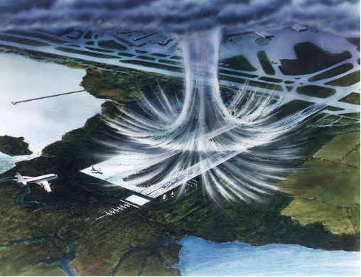
One of the most dangerous aspects of turbulence in a thunderstorm is the weather phenomenon known as microbursts. A microburst is a sudden, unexpected, and severe downdraft. Although these normally occur near and around thunderstorms they can cause wind shear of over 45 knots in the opposite direction!
 Icing is perhaps the deadliest part of a thunderstorm for small aircraft. A thunderstorm is a breeding ground for ice. The storm contains ample moisture, cool temperatures, and updrafts which can cause icing in a matter of minutes (if not seconds). Even the most advanced de-icing systems will struggle in cumulonimbus cloud icing.
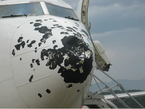 Aw hail no! The ugly twin cousin of thunderstorm ice is hail. Hail’s destructive power is just as bad on your airplane as it is on your car. Additionally, a thunderstorm powerful enough can toss hail miles away from the central cumulonimbus cloud the storm calls home.
Lightning, by itself, is a rather rare way to bring down an airplane. Most airplanes are equipped with whisks for divert lighting away from the vital parts of the plane if struck. But lighting can cause another major issue, not with the plane, but with you–blindness. Lighting can cause momentary (or even permanent blindness) in the pilot. The dangers of this are obvious. But it plays into a greater issue of thunderstorms, and severe loss of visibility.
Don’t Skirt Around the Cumulonimbus Clouds
Often pilots may try to “skirt around” the edge of a thunderstorm and maintain VFR. Bad idea. A thunderstorm can grow and unload massive amounts of water in seconds. (the average thunderstorm holds enough water to fill 416 Olympic-sized pools!) The hole you thought was there can rapidly disappear. Rest assured if you get near a thunderstorm– you will be in IMC before you know it.
The best way to understand a thunderstorm is on the ground. And Angle of Attack just happens to have the best online ground school in the industry. Our Private, Instrument, and Commercial programs will make sure you know how to avoid thunderstorms and you can even stay dry while doing it!

Michael Brown grew up flying on the banks of the Tennessee River in Chattanooga, TN. He obtained his private pilot’s license in high school and has instrument and seaplane ratings. Michael graduated from Texas Christian University, where he founded the school’s flying club, with a double major in Business and Communications. He is currently a law student at Tulane University, studying transportation law. Michael was named the Richard Collins Young Writing Award winner and has had his legal writing recognized by the American Bar Association’s Air & Space Subcommittee. When he is not flying or studying, Michael enjoys riding his bike and cheering on his Atlanta Braves.

ON THE SAME TOPIC
FAA PPL Written Test Scheduling Guide
Are you ready to take the next step in your aviation journey by scheduling your FAA PPL written test? An essential milestone for any pilot is passing the FAA PPL (Private Pilot License) written test. Understanding the ins and outs of scheduling this exam is crucial for a smooth experience. In this guide, we’ll walk …
FAA PPL Written Test Scheduling Guide »
Navigating Through General Aviation’s Diverse Aircraft Categories & Classes
General Aviation serves as the heartbeat of the aviation world, encompassing all non-commercial and non-military aviation activities. It presents a versatile array, each distinct in design, purpose, and capability. This article delves deeply into the various categories and classes within general aviation, exploring the functionalities, applications, and importance of each. General Aviation Categories: The world …
Navigating Through General Aviation’s Diverse Aircraft Categories & Classes »

Collision Avoidance, What are your Pilot Responsibilities?
Collision avoidance in aviation is a critical aspect of ensuring the safety of both passengers and crew aboard an aircraft. It involves several strategies and systems that help in preventing mid-air collisions, ground collisions, and other accidents. Pilots play a pivotal role in the execution of collision avoidance measures, utilizing advanced technology, effective communication, and …
Collision Avoidance, What are your Pilot Responsibilities? »
What Are Hazardous Attitudes in Aviation?
In the aviation domain, safe operation is a cardinal priority, vital for protecting life, property, and the environment. The FAA recognizes that while technical error contributes to unsafe conditions, human attitudes significantly influence decision-making and behavior, thereby affecting overall flight safety. Five hazardous attitudes have been identified that can compromise safety in aviation: anti-authority, impulsivity, …
What Are Hazardous Attitudes in Aviation? »

Stay Connected
Be the very first to get notified when we publish new flying videos, free lessons, and special offers on our courses.
