
AIM Text
- Vehicle Roadway Markings. The vehicle roadway markings are used when necessary to define a pathway for vehicle operations on or crossing areas that are also intended for aircraft. These markings consist of a white solid line to delineate each edge of the roadway and a dashed line to separate lanes within the edges of the roadway. In lieu of the solid lines, zipper markings may be used to delineate the edges of the vehicle roadway. (See FIG 2-3-18.) Details of the zipper markings are shown in FIG 2-3-19.
- VOR Receiver Checkpoint Markings. The VOR receiver checkpoint marking allows the pilot to check aircraft instruments with navigational aid signals. It consists of a painted circle with an arrow in the middle; the arrow is aligned in the direction of the checkpoint azimuth. This marking, and an associated sign, is located on the airport apron or taxiway at a point selected for easy access by aircraft but where other airport traffic is not to be unduly obstructed. (See FIG 2-3-20.)
FIG 2-3-17
Holding Position Markings: Taxiway/Taxiway IntersectionsFIG 2-3-18
Vehicle Roadway Markings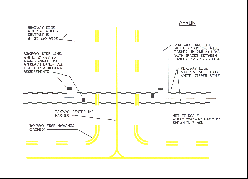
FIG 2-3-19
Roadway Edge Stripes, White, Zipper Style - Nonmovement Area Boundary Markings. These markings delineate the movement area (i.e., area under ATC). These markings are yellow and located on the boundary between the movement and nonmovement area. The nonmovement area boundary markings consist of two yellow lines (one solid and one dashed) 6 inches (15cm) in width. The solid line is located on the nonmovement area side, while the dashed yellow line is located on the movement area side. The nonmovement boundary marking area is shown in FIG 2-3-21.
FIG 2-3-20
Ground Receiver Checkpoint MarkingsFIG 2-3-21
Nonmovement Area Boundary MarkingsFIG 2-3-22
Closed or Temporarily Closed Runway and Taxiway Markings - Marking and Lighting of Permanently Closed Runways and Taxiways. For runways and taxiways which are permanently closed, the lighting circuits will be disconnected. The runway threshold, runway designation, and touchdown markings are obliterated and yellow crosses are placed at each end of the runway and at 1,000 foot intervals. (See FIG 2-3-22.)
FIG 2-3-23
Helicopter Landing Areas
- Temporarily Closed Runways and Taxiways.To provide a visual indication to pilots that a runway is temporarily closed, crosses are placed on the runway only at each end of the runway. The crosses are yellow in color. (See FIG 2-3-22.)
- A raised lighted yellow cross may be placed on each runway end in lieu of the markings described in Subparagraph e,Temporarily Closed Runways and Taxiways, to indicate the runway is closed.
- A visual indication may not be present depending on the reason for the closure, duration of the closure, airfield configuration, and the existence and the hours of operation of an airport traffic control tower. Pilots should check NOTAMs and the Automated Terminal Information System (ATIS) for local runway and taxiway closure information.
- Temporarily closed taxiways are usually treated as hazardous areas, in which no part of an aircraft may enter, and are blocked with barricades. However, as an alternative, a yellow cross may be installed at each entrance to the taxiway.
- Helicopter Landing Areas.The markings illustrated in FIG 2-3-23 are used to identify the landing and takeoff area at a public use heliport and hospital heliport. The letter “H” in the markings is oriented to align with the intended direction of approach. FIG 2-3-23 also depicts the markings for a closed airport.
Source: FAA Aeronautical Information Manual · current edition · paragraph 2-3-6.
The short answer
AIM 2-3-6 is FAA advisory guidance on other airport markings: vehicle roadway markings, VOR receiver checkpoint markings, nonmovement area boundary markings, marking of permanently and temporarily closed runways/taxiways, and helicopter landing areas. It describes their colors, dimensions, and meaning to aid surface awareness, supporting compliant ground operations under 14 CFR 91.129.
Research Notes
Common Questions
What do yellow crosses on a runway mean?
Per AIM 2-3-6, yellow crosses indicate a closed runway. For permanently closed runways the threshold, designation, and touchdown markings are obliterated and yellow crosses are placed at each end and at 1,000 foot intervals; for temporarily closed runways crosses are placed only at each end. Pilots should check NOTAMs and ATIS for closure information.
What are nonmovement area boundary markings?
AIM 2-3-6 states nonmovement area boundary markings delineate the movement area (area under ATC). They consist of two yellow lines — one solid and one dashed — 6 inches (15 cm) in width. The solid line is on the nonmovement area side and the dashed line is on the movement area side.
What is a VOR receiver checkpoint marking on the apron?
Per AIM 2-3-6, the VOR receiver checkpoint marking lets the pilot check aircraft instruments against navigational aid signals. It is a painted circle with an arrow aligned in the direction of the checkpoint azimuth, located on the apron or taxiway. An associated sign shows the VOR identification letter, course (e.g., DCA 176-356), the words “VOR check course,” and DME data when applicable, in black on a yellow background.