
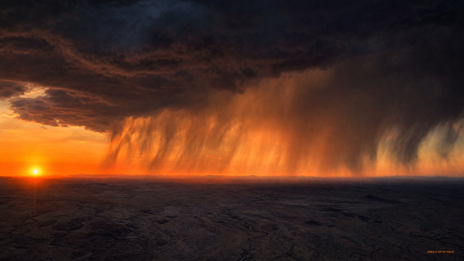
What Is Virga? The Hanging Rain That Warns of Wind Shear
Virga is precipitation — rain, snow, or ice crystals — that falls from a cloud but evaporates or sublimates in dry air before it reaches the ground, leaving wispy, trailing streaks that hang beneath the cloud base like a ragged curtain. For a pilot, virga is more than a pretty sight. That evaporation cools the air, which then sinks fast, and those invisible downdrafts can produce gusty winds, sudden wind shear, and even microbursts near the surface. So when you see virga, you’re not just looking at weather — you’re reading a warning sign.
That’s the short version. But virga sits at the crossroads of several things a student pilot needs to understand cold: how precipitation forms, how dry air drives evaporative cooling, why downdrafts happen, and how all of that turns into wind shear that can wreck an approach. This article walks through every piece — the science, the cockpit hazards, the how-to, and the test.
- Virga is evaporating precipitation. It falls from a cloud but never reaches the ground because it evaporates (rain) or sublimates (ice/snow) in dry air below the cloud base.
- The name comes from Latin — virga means “rod” or “twig,” describing the streaky, trailing appearance hanging beneath the cloud.
- Virga signals dry air below the cloud, exactly the setup needed for strong evaporative cooling and fast-sinking air.
- The real hazard is the downdraft. Evaporative cooling makes air denser, so it accelerates toward the ground, producing gusty surface winds and wind shear.
- Virga is a classic visual cue for a microburst — a small, intense downdraft that can exceed 6,000 feet per minute and is extremely dangerous on takeoff and landing.
- Most virga encounters are benign — but that’s exactly what makes the dangerous ones so deadly. Pilots who’ve flown under virga without incident learn to discount the hazard.
- It’s most common in dry climates — the high desert, the intermountain West, and the interior of Alaska — where low-level humidity is low.
- You can’t always feel it coming. The wind shift may reach the surface with little warning, which is why seeing the virga first matters so much.
WHAT’S IN THIS GUIDE
- 1What does virga mean and where does the word come from?
- 2How does virga actually form?
- 3Why is virga dangerous for pilots?
- 4What is the connection between virga and microbursts?
- 5How does virga cause wind shear?
- 6Where and when are you most likely to see virga?
- 7What is the difference between virga and other precipitation?
- 8How do you spot virga and react in the cockpit?
- 9What are the most common misconceptions about virga?
- 10PLT Study Guide
- 11Frequently Asked Questions
What does virga mean and where does the word come from?
Virga is precipitation that falls out of a cloud and evaporates before it ever touches the ground. The word comes from Latin — virga means “rod,” “branch,” or “twig” — and it describes exactly what you see: thin, fibrous streaks of rain or ice trailing down from the cloud base, fraying out into nothing partway to the earth. Meteorologists call those trailing streaks “fallstreaks.”
You’ll hear virga called “ghost rain” or “phantom rain,” which captures it well. From the cockpit it looks like the sky is bleeding gray ribbons that just stop in midair. The cloud is clearly raining — but the rain dies on the way down.
The opposite condition, where precipitation does reach the surface, is called praecipitatio. Virga is the in-between state: a cloud is producing precipitation, but the air column below it is dry enough to consume that precipitation before it lands. That distinction — cloud producing rain versus rain reaching the ground — is the whole story behind why virga matters to a pilot.
How does virga actually form?
Virga forms when precipitation falls into a layer of dry air, and that dry air evaporates the falling droplets (or sublimates the ice crystals) faster than they can reach the ground. The drier and deeper that low-level air is, the more precipitation gets consumed on the way down — and the more dramatic the virga.
Here’s the chain. A cloud builds enough moisture to start producing precipitation. As raindrops or ice crystals fall out of the cloud base, they enter air that is unsaturated — low relative humidity and a wide temperature-dewpoint spread. In that dry air, the falling water changes phase: liquid evaporates and ice sublimates directly to vapor. Each droplet shrinks as it descends, and if the dry layer is deep enough, it vanishes completely before impact.
The key number to watch on your weather briefing: a surface temperature-dewpoint spread of 30–50°F (roughly 17–28°C) signals very dry low-level air — the classic setup for virga-favorable conditions. You can pull that spread off any standard briefing. When you see it and high-based convective clouds are in the forecast, treat any clouds you see as potential dry-microburst sources until proven otherwise.
There’s a second, more important effect hiding in that evaporation. Evaporation is a cooling process — it pulls latent heat out of the surrounding air. So as the precipitation evaporates, it chills the air around it. Cooler air is denser, and denser air sinks. Normally, descending air warms as it sinks — the dry adiabatic lapse rate runs about 3°C per 1,000 feet (PHAK FAA-H-8083-25C, Ch. 12), which is why a sinking parcel should heat up and lose its drive. But here the falling precipitation keeps evaporating into that descending air, refreshing the cooling faster than compression can warm it. The column stays colder and denser than its surroundings, so it keeps accelerating instead of stalling out. The result is a slug of cold, heavy air plunging downward beneath the cloud. That sinking air is the part of virga that can hurt you.
Why is virga dangerous for pilots?
Virga is dangerous because it produces strong, often invisible downdrafts and the wind shear that comes with them. The evaporative cooling beneath the cloud creates a slug of cold, dense air that plunges toward the ground and spreads outward when it hits the surface. Near an airport, that means sudden gusts, rapid airspeed changes on approach, and — in the worst case — a microburst.
The trap with virga is that it can look harmless. The rain isn’t even reaching the ground, so it’s easy to file it under “scenery” rather than “threat.” But here’s the counterintuitive truth: the more vigorously the precipitation evaporates, the stronger the downdraft — so virga that disappears high above the ground can produce a more violent sinking column than rain that makes it most of the way down. Dry-microburst events are notorious precisely because there’s so little rain to warn you.
To make the hazard concrete: a Cessna 172 at gross weight under density-altitude conditions has a best-rate climb around 700 fpm. A mature microburst downdraft can reach 6,000 fpm (AIM 7-1-24). The math is unambiguous — the airplane cannot outclimb it. You can’t muscle your way out with technique. The only winning move is not flying through it in the first place.
The FAA’s Pilot’s Handbook of Aeronautical Knowledge (PHAK FAA-H-8083-25C, Ch. 12) and Advisory Circular AC 00-54, Pilot Wind Shear Guide, both flag virga as a visible indicator of potential wind shear and downdraft activity. AC 00-54 states it plainly — virga may precede a microburst — and then goes further with the hardest sentence in the whole document: “SOME MICROBURSTS CANNOT BE SUCCESSFULLY ESCAPED WITH ANY KNOWN TECHNIQUES.”
That one sentence should reset how you think about virga. This is not about having the right recovery procedure. This is about avoidance.
What is the connection between virga and microbursts?
Virga is one of the most reliable visual indicators of a possible microburst. A microburst is a small but extremely intense, concentrated downdraft — typically less than 2.5 nautical miles across at the surface — that can generate downdrafts of up to 6,000 feet per minute and headwind-to-tailwind shear of up to 90 knots total swing (AIM 7-1-24). The same dry-air evaporative cooling that creates virga is the engine that spins up a dry microburst.
Wet versus dry
There are two flavors. A wet microburst comes with heavy rain — you can see the dark shaft. A dry microburst comes with little or no rain reaching the ground, and virga is its calling card. In dry climates you may see nothing but high-based clouds and those fraying streaks, while underneath, a violent column of cold air accelerates toward the runway. The dry kind is more insidious precisely because there’s less visual drama at the surface.
The lifecycle that pilots miss
The timing detail almost no training resource mentions: a microburst keeps intensifying for approximately 5 minutes after it hits the ground, peaks for 2–4 minutes, then dissipates. Total lifespan is typically under 15 minutes (AIM 7-1-24). This matters for go/no-go decisions in two ways. First, the most dangerous period isn’t when the outflow appears at the surface — it’s just after, when intensity is still climbing. Second, a microburst that was reported on final by the aircraft ahead of you may be at peak or fading by the time you’re on approach. That variability is not reassurance — it’s reason to hold.
The ring of dust — and why it comes too late
You’ll often read that a ring of blowing dust is a warning sign of a microburst. That’s true — but the timing is critical. That dust ring appears after the downdraft has already hit the ground. If you’re on a two-mile final in a light airplane when the ring appears, you may already be inside the hazard zone. The visual cue arrives after you needed it. This is exactly why spotting the virga from a distance — before you’re committed to the approach — is the whole game.
The headwind-to-tailwind trap
Here’s the sequence that kills pilots. On approach into a microburst: the initial outflow produces a headwind, which increases indicated airspeed and makes the airplane balloon above glide path. The natural reaction is to reduce power. Then the downburst core slams the aircraft. Then the tailwind on the far side reduces airspeed just as you have the least energy. You firewall the throttle too late, and you’re out of altitude. The initial performance gain is what masks the threat — it feels like everything is fine right up until it isn’t.
Delta Flight 191 (DFW, August 2, 1985) is the case study: a Lockheed L-1011 on approach encountered microburst-induced wind shear with this exact sequence. 137 fatalities. NTSB report AAR-86/05. That accident drove the LLWAS requirements and the creation of AC 00-54. It was a wet microburst — dark rain shaft visible. The dry kind, announced only by virga, gives you even less warning.
How does virga cause wind shear?
Virga causes wind shear because the cold downdraft it produces doesn’t just stop at the surface — it spreads out horizontally in all directions, creating sharp changes in wind speed and direction over short distances. Wind shear is a rapid change in wind velocity across a small horizontal or vertical span, and the outflow from a virga-driven downdraft is a textbook source of it near the ground.
Picture the cold air column hitting the surface like water from a faucet hitting a sink — it splashes outward in a circular pattern. An airplane flying through that outflow on approach gets a headwind on one side and a tailwind on the other, with the strong downdraft in the middle. The airspeed indicator swings, the airplane balloons and then sinks. That’s low-level wind shear — the FAA defines it as shear below 2,000 feet AGL — and it’s most dangerous close to the ground on takeoff and landing, where you have no room to recover.
The Aeronautical Information Manual (AIM 7-1-24, Microbursts) and Advisory Circular AC 00-54 both describe this outflow and the danger it poses during takeoff and landing. Virga is one of the few wind-shear sources you can actually see from the cockpit before you fly into it — which is exactly why learning to recognize it is worth your time.
One more detail on the detection gap: virga has no standard METAR code. It doesn’t appear in the observation string. The official warning system is pilot reports (PIREPs), Low-Level Wind Shear Alert System (LLWAS) alerts at equipped airports, and wind-shear SIGMETs/AIRMETs. At a non-towered airport without LLWAS, the windsock is your only real-time warning system. If you’re flying into a dry-climate airport on a summer afternoon, the weather briefing and your own eyeballs are doing the work — there’s no automated alert between you and the hazard.
| Wind shear source | What you see | Where it bites |
|---|---|---|
| Virga / dry microburst | Trailing rain streaks, high-based clouds, little surface rain | Approach and departure in dry climates |
| Wet microburst / thunderstorm | Heavy rain shaft, dark cloud base, lightning | Near and under convective cells |
| Frontal passage | Wind shift, temperature change, cloud line | Low levels during/after front |
| Low-level temperature inversion | Smooth layer, smoke trapped, calm surface | Climb-out through the inversion top |
| Mountain wave / rotor | Lenticular clouds (indirect cue) | Mountain downwind, year-round |
Where and when are you most likely to see virga?
Virga is most common in dry climates and at higher elevations, where the air beneath the cloud base is dry enough to evaporate falling precipitation. Think the desert Southwest, the Great Basin and intermountain West, the high plains, and the interior of Alaska — anywhere the low-level relative humidity is low and the temperature-dewpoint spread is wide. It also shows up worldwide on summer afternoons when high-based convective clouds build over dry surface air.
Timing matters too. Virga is often a warm-season, afternoon phenomenon, because daytime heating drives the convection that builds the clouds while the surface air stays dry. You’ll see it most around high-based cumulus and altocumulus, and trailing from the anvils of distant thunderstorms. In winter and at altitude, you’ll see virga made of ice crystals sublimating out of high cirrus — usually benign for low-level operations, but it still tells you the air aloft is dry.
One thing worth emphasizing: virga does not require a thunderstorm. You can see it trailing from ordinary cumulus and altocumulus on an afternoon with no cumulonimbus in sight — no lightning, no SIGMET, nothing to trigger a divert in the conventional sense. Yet the resulting downdraft is real. Don’t wait for the system to look serious before you take the streaks seriously.
What is the difference between virga and other precipitation?
The difference is simple but important: virga is precipitation that does not reach the ground, while ordinary rain, snow, or showers do. The cloud is producing precipitation in both cases — the deciding factor is whether the air below the cloud is dry enough to evaporate or sublimate that precipitation before it lands.
It helps to separate a few terms students mix up. Precipitation is any water — liquid or solid — that falls from a cloud; when it reaches the surface it’s praecipitatio, and when it evaporates first it’s virga. A “rain shaft” is the visible column of precipitation reaching the ground beneath a cumulonimbus — the opposite of virga, heavy enough and the air moist enough that it makes it all the way down. Mist and fog, by contrast, aren’t falling precipitation at all; they’re suspended droplets near the surface.
| Feature | Virga | Rain shaft | Fog/mist | Hail |
|---|---|---|---|---|
| Reaches ground? | No | Yes | Originates at surface | Yes |
| Cause | Dry air evaporates falling precip | Saturated column below cloud | Cooling/saturation near surface | Updraft freezing |
| Visual cue | Streaks fading mid-air | Solid shaft to ground | Low-lying gray layer | Haze/shafts at cloud base |
| Main pilot hazard | Downdraft, wind shear, dry microburst | Reduced visibility, icing | Ceiling/vis reduction | Structural damage |
| Climate association | Dry, high-elevation | Universal | Humid/calm | Convective |
| METAR code | None standard | RA / SN / etc. | FG / BR / etc. | GR / GS |
The phase of the precipitation doesn’t change whether it counts as virga. Rain virga evaporates; snow and ice-crystal virga sublimate (going straight from solid to vapor). Both leave the same trailing streaks, and both signal dry air below the cloud.
How do you spot virga and react in the cockpit?
Spotting virga is mostly about training your eye: look for soft, gray, fibrous streaks trailing from a cloud base that fade out and never reach the ground, often beneath high-based cumulus or altocumulus in dry conditions. If your pre-flight briefing showed a temperature-dewpoint spread of 30°F or more in the low levels and afternoon convection is in the picture, your eyes should be scanning for those streaks before you’re anywhere near the field.
Once you see virga, the most important decision you make is the one before you’re committed. Decide ahead of time what you will and won’t do. If virga is over or near the departure or destination airport, your threshold for holding or diverting should already be set — not negotiated in your head on short final.
In the cockpit, your reactions come down to a few habits:
Give it a wide berth. Virga is not something to fly under or through on purpose, because that’s where the downdraft and outflow live.
Watch the airspeed on approach. The shear signature is a sudden gain followed by a loss. If you see that combination and spot virga near the field, go around early and decisively — not late.
Carry extra airspeed. When wind shear is a possibility, add the standard gust factor (half the gust spread above approach speed) per AC 00-54 guidance. A little extra energy on final buys you seconds.
Know the recovery — but don’t rely on it. If you do encounter shear on short final: maximum available power, pitch to the recommended attitude, don’t chase the airspeed needle down. But remember what AC 00-54 says: some microbursts cannot be escaped. The recovery procedure is the backstop; avoidance is the strategy.
The microburst encounter profile and the exact recovery technique deserve their own deep dive — but the headline is simple: avoidance beats recovery every time.
This kind of weather judgment — not just memorizing definitions but reading what the sky is actually telling you — is what we build from day one in the Private Pilot Ground School.
What are the most common misconceptions about virga?
“No rain on the ground means no hazard.” This is the most dangerous one. The evaporation that prevents the rain from landing is the same process that creates the dangerous downdraft. No rain on the ground can mean the hazard is a dry microburst — which is among the deadliest kinds.
“Virga only matters near thunderstorms.” It often forms near convection, but ordinary high-based cumulus and altocumulus can produce hazardous virga on a dry afternoon with no thunderstorm in sight. The cloud doesn’t have to be a towering cumulonimbus to produce a strong sinking column.
“I’ve flown under virga before and it was fine.” This one is the most psychologically dangerous. Most virga encounters genuinely are benign — the air underneath is calm, or even rising in some cases. That variability is what creates complacency. Pilots who have flown under virga without consequence learn to discount it. The hazard is the potential, not the certainty — and the one time the downdraft is active, prior safe encounters offer zero protection.
“The dust ring is an early warning.” The ring of blowing dust at the surface appears after the microburst hits the ground. If you see it on final, you may already be inside the hazard. It’s confirmation, not a heads-up.
“Virga and fog are similar because they both look gray and wispy.” They’re not. Fog is saturated air at the surface; virga is the product of unsaturated, dry air below a cloud — opposite humidity conditions. A wide temperature-dewpoint spread produces virga; a near-zero spread with light winds produces fog.
PLT Study Guide
The FAA tags knowledge-test questions with PLT (Pilot Learning Statement) codes. The codes below map directly to virga and its hazards.
PLT344 — Recall precipitation: types / characteristics. The core code for virga. Virga is precipitation — its defining characteristic is that it evaporates or sublimates before reaching the ground. Know the types (rain, drizzle, snow, ice crystals) and that the deciding factor for virga is dry air below the cloud consuming the falling precipitation.
PLT512 — Recall weather conditions: temperature / moisture / dewpoint. Virga is a moisture-and-dewpoint story. A wide temperature-dewpoint spread means dry, unsaturated low-level air — the exact condition that evaporates falling rain and drives the cooling behind the downdraft. Connect “big spread = dry air = virga-favorable.” The threshold that matters: 30–50°F spread in the low levels.
PLT317 — Recall microburst: characteristics / hazards. Virga is a classic visual indicator of a possible microburst. Key numbers from AIM 7-1-24: horizontal extent less than 2.5 nautical miles, downdrafts up to 6,000 fpm, surface outflow up to 45 knots, headwind-to-tailwind shear up to 90 knots total swing, total duration under 15 minutes, with the outflow intensifying for about 5 minutes after ground contact and peak-intensity winds lasting 2–4 minutes.
PLT518 — Recall windshear: characteristics / hazards / power management. The practical hazard virga warns of is low-level wind shear (below 2,000 feet AGL per FAA). Understand the headwind-to-tailwind reversal, why it bites hardest close to the ground on takeoff and landing, and the power-management response: maximum available power, pitch to recommended attitude, go around early. And remember the AC 00-54 caveat — some encounters cannot be escaped.
PLT495 — Recall thunderstorms: types / characteristics / formation / hazards / precipitation static. Virga frequently trails from the bases and anvils of thunderstorms, so questions linking the two are fair game. Know that the convective downdraft and outflow are core thunderstorm hazards, and that virga can mark them even where the storm’s rain isn’t reaching the ground.
Microburst key numbers for the test
| Parameter | Value | Source |
|---|---|---|
| Horizontal extent | Less than 2.5 NM | AIM 7-1-24 |
| Max downdraft | Up to 6,000 fpm | AIM 7-1-24 |
| Surface outflow | Up to 45 knots | AIM 7-1-24 |
| Total wind shear swing | Up to 90 knots | AIM 7-1-24 / AC 00-54 |
| Total duration | Under 15 minutes | AIM 7-1-24 |
| Peak intensity duration | 2–4 min | AIM 7-1-24 |
| Post-impact intensification | ~5 min of increasing intensity | AIM 7-1-24 |
| Temp-dewpoint spread threshold | 30–50°F low-level | AC 00-54 |
Frequently Asked Questions
Is virga dangerous to fly through?
Yes. The streaks themselves are just evaporating precipitation, but the air beneath and around virga can contain strong downdrafts, gusty outflow, and low-level wind shear — including dry microbursts. Avoid flying under or through virga, especially on approach or departure where you have no altitude to recover.
Does virga always mean a microburst is present?
No — and this is the critical nuance. Most virga encounters are benign. The air beneath may be calm or even rising. But virga signals the dry-air evaporative cooling that can produce a microburst, and it’s a recognized visual indicator of dry-microburst conditions (AC 00-54). The problem is that the benign majority creates complacency that gets pilots killed when the hazardous minority shows up. Treat virga near your flight path as a wind-shear threat until you can confirm otherwise.
Why doesn’t the rain from virga reach the ground?
Because the air below the cloud is dry and unsaturated. As the raindrops or ice crystals fall into that dry layer, they evaporate (rain) or sublimate (ice), shrinking as they descend. A temperature-dewpoint spread of 30–50°F in the low levels is the classic setup. If the dry layer is deep enough, the precipitation disappears entirely before it can reach the surface.
What does virga look like from the cockpit?
It looks like soft, gray, fibrous streaks trailing down from a cloud base and fraying out into nothing partway to the ground — never connecting to the surface. You’ll most often see it beneath high-based cumulus or altocumulus in dry, hot conditions, and trailing from distant thunderstorm anvils.
Where is virga most common in the United States?
In dry, high-elevation regions: the desert Southwest, the Great Basin and intermountain West, the high plains, and the interior of Alaska during hot summer afternoons. Anywhere the low-level air is dry — a wide temperature-dewpoint spread — favors virga.
Can virga come from non-thunderstorm clouds?
Yes. This is one of the most underemphasized points in standard training. Altocumulus and ordinary cumulus can produce virga and the resulting dry-microburst downdrafts without any cumulonimbus or thunderstorm conditions present. Don’t wait for a SIGMET before you take the streaks seriously.
Is virga the same as a rain shaft?
No. A rain shaft is a visible column of precipitation that reaches the ground, usually under a cumulonimbus. Virga is precipitation that evaporates before it lands. Same cloud-producing-rain start, opposite ending — the rain shaft makes it down, the virga doesn’t.
Can virga be made of snow or ice instead of rain?
Yes. In cold or high-altitude conditions, virga can be ice crystals or snowflakes that sublimate — go straight from solid to vapor — in dry air before reaching the ground. It produces the same trailing-streak appearance and still indicates dry air below the cloud.
Does virga show up in METARs?
No. Virga has no standard METAR code and will not appear in the observation string. The official warning system is pilot reports (PIREPs), LLWAS alerts at equipped airports, and wind-shear SIGMETs/AIRMETs. At non-towered airports without LLWAS, the windsock and your own visual observation are the only real-time signals you have.
Does virga cause turbulence?
It can. The sinking, accelerating downdraft and the gusty outflow it creates near the surface are sources of turbulence and wind shear, particularly at low altitude. The turbulence is tied to the air motion under the virga, not the visible streaks themselves.
Should I cancel a flight because of virga?
Not necessarily — but respect it. Decide ahead of time what your threshold is, before you’re looking at the streaks on final. If virga is over or near your departure or destination, factor in the wind-shear risk, check ATIS/ASOS for shifting winds, and be willing to delay, hold, or divert. The right move is judgment and pre-briefed minimums, not a blanket cancellation — but also not wishful thinking.
Virga is one of those weather signs that separates pilots who memorized definitions from pilots who actually read the sky. Those gray streaks aren’t scenery — they’re the atmosphere telling you, in plain sight, that dry air, sinking cold, and wind shear may be waiting below. The dangerous thing about virga isn’t just the physics. It’s that most of the time, nothing happens. That track record makes it easy to discount. Being a safe pilot is a practice and a decision — and the virga go/no-go call is exactly where that practice gets tested.
Learn to see them, respect what they mean, and you’ll make better calls than half the people on the field.
Master every system on your checkride — and on day one.
The Private Pilot Ground School breaks down every FAA subject area in the same plain-English, real-world way you just read — with quizzes, scenarios, and the explanations that finally make it click.
Angle of Attack has been building pilots who can read weather instead of just recite it since 2006, and Chris has been a CFI since 2017. That’s the whole goal: not just checkride-ready, but day-one ready, with the judgment to stay ahead of the airplane.


ON THE SAME TOPIC

IFR vs VFR: The Two Sets of Rules Every Pilot Flies By
IFR vs VFR: The Two Sets of Rules Every Pilot Flies By 19 min read Last updated June 2026 · Chris Palmer The difference between IFR and VFR is which set of rules you fly under. VFR — visual flight rules — lets you navigate by looking outside and staying clear of clouds in good […]
 Read more
ASOS vs AWOS vs ATIS: How to Pull the Right Weather Before You Fly
ASOS vs AWOS vs ATIS: How to Pull the Right Weather Before You Fly 13 min read Last updated June 2026 · Chris Palmer The difference comes down to who is talking and what the broadcast covers. ASOS and AWOS are automated, computer-generated weather observations of the conditions right at the field. ATIS is a […]
Read more 
What Is RNAV Navigation? Area Navigation for VFR Pilots
What Is RNAV Navigation? Area Navigation for VFR Pilots 17 min read Last updated June 2026 · Chris Palmer RNAV — Area Navigation — is a method that lets an aircraft fly any desired path within the coverage of ground- or space-based navigation aids, rather than being forced to fly directly to and from stations. […]
Read more 
NDB and ADF Explained: The Oldest Radio Nav System You Still Need to Understand
NDB and ADF Explained: The Oldest Radio Nav System You Still Need to Understand 16 min read Last updated June 2026 · Chris Palmer An NDB (non-directional beacon) is a ground-based radio transmitter that sends a signal in all directions, and an ADF (automatic direction finder) is the cockpit receiver whose needle points straight at […]
Read more 
Stay Connected
Be the very first to get notified when we publish new flying videos, free lessons, and special offers on our courses.
