
AIM Text
- Location signs are used to identify either a taxiway or runway on which the aircraft is located. Other location signs provide a visual cue to pilots to assist them in determining when they have exited an area. The various location signs are described below.
- Taxiway Location Sign.This sign has a black background with a yellow inscription and yellow border, as shown in FIG 2-3-30. The inscription is the designation of the taxiway on which the aircraft is located. These signs are installed along taxiways either by themselves or in conjunction with direction signs or runway holding position signs. (See FIG 2-3-35 and FIG 2-3-31.)
FIG 2-3-32
Runway Location Sign
FIG 2-3-33
Runway Boundary Sign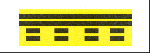
- Runway Location Sign.This sign has a black background with a yellow inscription and yellow border, as shown in FIG 2-3-32. The inscription is the designation of the runway on which the aircraft is located. These signs are intended to complement the information available to pilots through their magnetic compass and typically are installed where the proximity of two or more runways to one another could cause pilots to be confused as to which runway they are on.
- Runway Boundary Sign.This sign has a yellow background with a black inscription with a graphic depicting the pavement holding position marking, as shown in FIG 2-3-33. This sign, which faces the runway and is visible to the pilot exiting the runway, is located adjacent to the holding position marking on the pavement. The sign is intended to provide pilots with another visual cue which they can use as a guide in deciding when they are “clear of the runway.”
FIG 2-3-34
ILS Critical Area Boundary Sign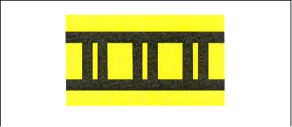
- ILS Critical Area Boundary Sign. This sign has a yellow background with a black inscription with a graphic depicting the ILS pavement holding position marking as shown in FIG 2-3-34. This sign is located adjacent to the ILS holding position marking on the pavement and can be seen by pilots leaving the critical area. The sign is intended to provide pilots with another visual cue which they can use as a guide in deciding when they are “clear of the ILS critical area.”
- Taxiway Location Sign.This sign has a black background with a yellow inscription and yellow border, as shown in FIG 2-3-30. The inscription is the designation of the taxiway on which the aircraft is located. These signs are installed along taxiways either by themselves or in conjunction with direction signs or runway holding position signs. (See FIG 2-3-35 and FIG 2-3-31.)
Source: FAA Aeronautical Information Manual · current edition · paragraph 2-3-9.
The short answer
AIM 2-3-9 is FAA advisory guidance on location signs that identify the taxiway or runway an aircraft is on, or cue pilots that they have exited an area. It covers taxiway location, runway location, runway boundary, and ILS critical area boundary signs, with their colors and purpose. It supports situational awareness during taxi under 14 CFR 91.129.
Research Notes
Common Questions
What does a taxiway location sign look like?
Per AIM 2-3-9, a taxiway location sign has a black background with a yellow inscription and yellow border. The inscription is the designation of the taxiway on which the aircraft is located. These signs are installed along taxiways either by themselves or in conjunction with direction signs or runway holding position signs.
What is a runway boundary sign and when is it used?
AIM 2-3-9 describes the runway boundary sign as having a yellow background with a black inscription and a graphic depicting the pavement holding position marking. It faces the runway, is visible to the pilot exiting the runway, and is located adjacent to the holding position marking on the pavement to help the pilot decide when the aircraft is “clear of the runway.”
How does a runway location sign differ from a runway boundary sign?
Per AIM 2-3-9, a runway location sign has a black background with a yellow inscription and yellow border, showing the designation of the runway the aircraft is on; it complements the magnetic compass and is installed where nearby runways could confuse pilots. The runway boundary sign instead has a yellow background with black inscription and a holding-position graphic, marking when the aircraft is clear of the runway.